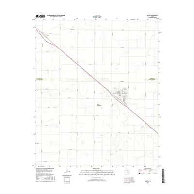
2016 Map of Anton
USGS Topo · Published 2016About this map
Anton and the nearby siding of Bainer anchor this portion of the South Plains, situated along the diagonal corridor of Old Hwy 84. This landscape is defined by the intersection of the Lamb Co and Hockley Co boundary and a rigid grid of rural roads named for distant states, such as Ohio, Nevada, and Maine Rd. The natural drainage of Yellow House Draw provides a subtle break in the agricultural geometry south of the main settlement. Local family researchers will find the Anton Cem clearly marked west of the town center, while the street-level detail in Anton includes specific residential thoroughfares like Santa Fe St and Duke Ave. The map reflects a region of intensive land management where county roads like Co Rd 352 and Co Rd 267 facilitate a network of farm-to-market connectivity.
Find a feature on this map
51 named features on this map. Tap any name to fly to it.
Don’t see what you’re looking for? This feature index may not catch every label — zoom into the map to look around manually.
Map Details
Editions of this 2016 Anton Map
This is the sole edition of this map. No revisions or reprints were ever made.
Other maps of this area

1954 · Brownfield
USGS Topo · 1:250,000

1957 · Anton
USGS Topo · 1:62,500

1957 · Wolfforth
USGS Topo · 1:62,500

1958 · Brownfield
USGS Topo · 1:250,000

1962 · Brownfield
USGS Topo · 1:250,000

1964 · Littlefield
USGS Topo · 1:24,000

1964 · Lums Chapel
USGS Topo · 1:24,000

1964 · Whitharral
USGS Topo · 1:24,000
1976 · Anton SW
USGS Topo · 1:24,000
1976 · Wolfforth NW
USGS Topo · 1:24,000