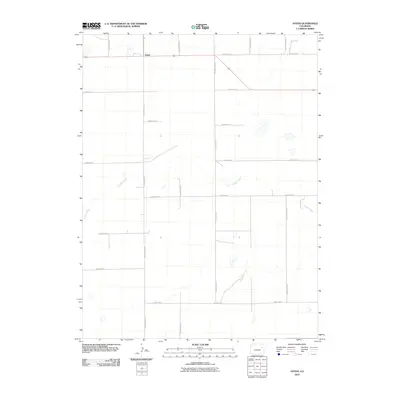
2010 Map of Anton
USGS Topo · Published 2010About this map
Anton sits at the intersection of early 21st-century rural transit routes in Washington County, marking a high-plains settlement defined by its grid of sectional roads. The landscape is primarily shaped by the drainage of Gordon Creek, which meanders across the central and western portions of the quadrangle. This survey illustrates the persistent importance of the county road network, featuring numbered and lettered routes such as County Rd-12 and County Road BB. The sparse distribution of named features reflects the character of the Colorado plains, where land use is dictated by the availability of water and the accessibility of these primary thoroughfares. Genealogists and local historians can use this map to pinpoint the exact orientation of farmsteads and rural properties relative to established routes like County Road CC and County Rd-8.
Find a feature on this map
16 named features on this map. Tap any name to fly to it.
Don’t see what you’re looking for? This feature index may not catch every label — zoom into the map to look around manually.
Map Details
Editions of this 2010 Anton Map
This is the sole edition of this map. No revisions or reprints were ever made.
Other maps of this area

1954 · Limon
USGS Topo · 1:250,000

1957 · Limon
USGS Topo · 1:250,000

1958 · Limon
USGS Topo · 1:250,000

1973 · Lindon NE
USGS Topo · 1:24,000

1973 · Antelope Creek SE
USGS Topo · 1:24,000

1973 · Shaw
USGS Topo · 1:24,000

1977 · Thurman
USGS Topo · 1:24,000
1977 · Elba SW
USGS Topo · 1:24,000

1977 · Arickaree
USGS Topo · 1:24,000

1977 · Elba SE
USGS Topo · 1:24,000