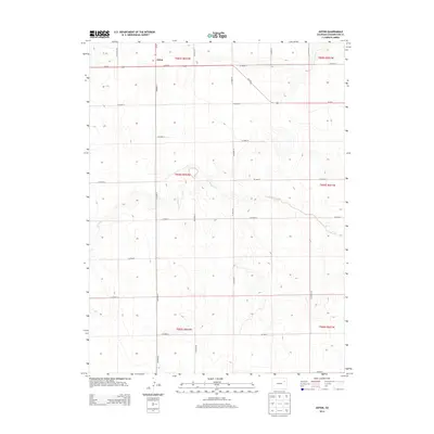
2013 Map of Anton
USGS Topo · Published 2013About this map
The unincorporated community of Anton serves as the primary focal point of this Eastern Colorado landscape, situated at the intersection of Us-36 E and Co-63. This 2013 survey illustrates the highly structured grid of the Public Land Survey System, where sections are clearly defined by a network of county roads ranging from Co Road 4 in the south to Co Road 12 in the north. The terrain is marked by the subtle drainage of Gordon Creek, which meanders eastward through the central portion of the quadrangle. The map reveals the characteristic settlement pattern of the High Plains, where human activity is largely tied to the intersections of these expansive section-line roads, such as Co Road CC and Co Road EE, which facilitate transit across the open agricultural and ranching lands of Washington County.
Find a feature on this map
26 named features on this map. Tap any name to fly to it.
Don’t see what you’re looking for? This feature index may not catch every label — zoom into the map to look around manually.
Map Details
Editions of this 2013 Anton Map
This is the sole edition of this map. No revisions or reprints were ever made.
Other maps of this area

1954 · Limon
USGS Topo · 1:250,000

1957 · Limon
USGS Topo · 1:250,000

1958 · Limon
USGS Topo · 1:250,000

1973 · Lindon NE
USGS Topo · 1:24,000

1973 · Antelope Creek SE
USGS Topo · 1:24,000

1973 · Shaw
USGS Topo · 1:24,000

1977 · Thurman
USGS Topo · 1:24,000
1977 · Elba SW
USGS Topo · 1:24,000

1977 · Arickaree
USGS Topo · 1:24,000

1977 · Elba SE
USGS Topo · 1:24,000