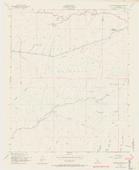
1943 Map of Apache Canyon
USGS Topo · Published 1971About this map
The high backcountry of Los Padres National Forest along the Kern and Ventura County line is documented here just after aerial surveys in 1942. This remote section of the Transverse Ranges is defined by the massive drainage systems of Apache Canyon and Quatal Canyon, where the landscape is punctuated by potreros—large, high-altitude grassy meadows such as Apache Potrero and Cowhead Potrero.
Find a feature on this map
24 named features on this map. Tap any name to fly to it.
Don’t see what you’re looking for? This feature index may not catch every label — zoom into the map to look around manually.
Map Details
Editions of this 1943 Apache Canyon Map
4 editions found
Other maps of this area

1903 · Mt. Pinos
USGS Topo · 1:125,000

1942 · Eagle Rest Peak
USGS Topo · 1:24,000

1942 · Ballinger Canyon
USGS Topo · 1:24,000

1943 · Rancho Nuevo Creek
USGS Topo · 1:24,000

1943 · Apache Canyon
USGS Topo · 1:24,000

1943 · San Guillermo
USGS Topo · 1:24,000

1943 · Sawmill Mountain
USGS Topo · 1:24,000

1943 · Santiago Creek
USGS Topo · 1:24,000
1943 · Ballinger Canyon
USGS Topo · 1:24,000

1943 · Cuyama Peak
USGS Topo · 1:24,000