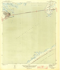
1943 Map of Apalachicola
USGS Topo · Published 1943About this map
The port of Apalachicola stands as the primary hub on this 1943 survey, situated at the mouth of the Apalachicola River where it meets the vast expanse of Apalachicola Bay. During the Second World War era, the Apalachicola Northern railroad provided a vital land link to the coast, while the John Gorrie Memorial Bridge connected the city eastward to Godleys Bluff and the settlement of Eastpoint.
Find a feature on this map
20 named features on this map. Tap any name to fly to it.
Don’t see what you’re looking for? This feature index may not catch every label — zoom into the map to look around manually.
Map Details
Editions of this 1943 Apalachicola Map
4 editions found
Other maps of this area

1943 · West Pass
USGS Topo · 1:31,680

1943 · Apalachicola
USGS Topo · 1:31,680

1943 · Jackson River
USGS Topo · 1:24,000

1944 · Green Point
USGS Topo · 1:31,680

1944 · Apalachicola
USGS Topo · 1:24,000

1945 · Cape St. George
USGS Topo · 1:31,680

1945 · Beverly
USGS Topo · 1:31,680

1945 · Jackson River
USGS Topo · 1:31,680

1949 · Apalachicola
USGS Topo · 1:250,000

1950 · Goose Island
USGS Topo · 1:31,680