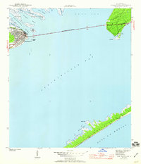
1943 Map of Apalachicola
USGS Topo · Published 1960About this map
The oyster-rich waters of Apalachicola Bay and the busy waterfront of Apalachicola anchor this 1943 survey, conducted as the coastal region served as a vital maritime corridor during the war years. The intricate delta system where the Apalachicola River meets the bay is clearly defined, showing the network of channels including the Little St Marks River and Scipio Creek. The town's grid extends toward the river mouth, with the long span of the John Gorrie Memorial Bridge reaching across the water to connect with the mainland near Godleys Bluff and the settlement at Eastpoint. To the south, the barrier protection of St George Island is visible with its characteristic Sand Dunes and sheltered inlets like Nicks Hole. This map provides an essential look at the physical layout of the Forgotten Coast before post-war development altered the shoreline and local infrastructure.
Find a feature on this map
22 named features on this map. Tap any name to fly to it.
Don’t see what you’re looking for? This feature index may not catch every label — zoom into the map to look around manually.
Map Details
Editions of this 1943 Apalachicola Map
4 editions found
Other maps of this area

1943 · West Pass
USGS Topo · 1:31,680

1943 · Apalachicola
USGS Topo · 1:31,680

1943 · Jackson River
USGS Topo · 1:24,000

1944 · Green Point
USGS Topo · 1:31,680

1944 · Apalachicola
USGS Topo · 1:24,000

1945 · Cape St. George
USGS Topo · 1:31,680

1945 · Beverly
USGS Topo · 1:31,680

1945 · Jackson River
USGS Topo · 1:31,680

1949 · Apalachicola
USGS Topo · 1:250,000

1950 · Goose Island
USGS Topo · 1:31,680