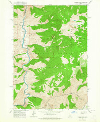
1963 Map of Aparejo Point
USGS Topo · Published 1964About this map
The Middle Fork Salmon River carves through the central Idaho wilderness, serving as the primary corridor for human activity in this remote region. This 1963 field-checked survey reveals the essential infrastructure of the era, including the Bernard Landing Field and Flying B Airport, which provided critical aerial access to the interior. Cultural landmarks like the Mormon Ranch and a nearby Cem reflect the sparse but enduring settlement history along the river banks.
Find a feature on this map
38 named features on this map. Tap any name to fly to it.
Don’t see what you’re looking for? This feature index may not catch every label — zoom into the map to look around manually.
Map Details
Editions of this 1963 Aparejo Point Map
3 editions found
Other maps of this area

1930 · Casto
USGS Topo · 1:125,000

1956 · Elk City
USGS Topo · 1:250,000

1957 · Challis
USGS Topo · 1:250,000

1960 · Elk City
USGS Topo · 1:250,000

1960 · Challis
USGS Topo · 1:250,000

1962 · Bear Creek Point
USGS Topo · 1:24,000

1962 · Hoodoo Meadows
USGS Topo · 1:24,000

1962 · Puddin Mtn
USGS Topo · 1:24,000

1962 · Dave Lewis Peak
USGS Topo · 1:24,000

1962 · Ramey Hill
USGS Topo · 1:24,000