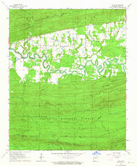
1963 Map of Aplin
USGS Topo · Published 1964About this map
The Fourche La Fave River carves a highly sinuous path through this 1963 survey of Perry County, Arkansas, defining the local topography between the settlements of Aplin and Cherry Hill. This landscape is characterized by the sharp transition from the fertile river bottoms to the steep ridges of the Ouachita National Forest. Local history is centered around the Pleasant Grove Ch and the adjacent Pleasant Grove Cem, which serve as a cultural anchor for the farming families in the valley. To the south, the terrain rises significantly toward Link Mountain and Cedar Mountain, where the Maumelle River flows through a more confined corridor. The network of light-duty roads and unimproved dirt tracks suggests a timber and agriculture-based economy, connecting smaller locales like Ragsdale to the primary river valley.
Find a feature on this map
23 named features on this map. Tap any name to fly to it.
Don’t see what you’re looking for? This feature index may not catch every label — zoom into the map to look around manually.
Map Details
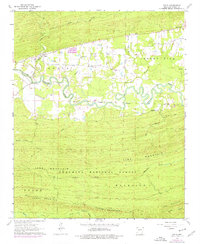
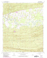
Editions of this 1963 Aplin Map
Other maps of this area

1888 · Dardanelle #4
USGS Topo · 1:62,500

1889 · Morrilton No. 3
USGS Topo · 1:62,500

1890 · Benton
USGS Topo · 1:125,000

1890 · Hot Springs
USGS Topo · 1:125,000

1890 · Dardanelle
USGS Topo · 1:125,000

1892 · Morrillton
USGS Topo · 1:125,000

1894 · Morrillton
USGS Topo · 1:125,000

1894 · Hot Springs
USGS Topo · 1:125,000

1894 · Benton
USGS Topo · 1:125,000

1955 · Little Rock
USGS Topo · 1:250,000