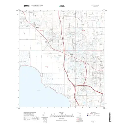
2021 Map of Apopka
USGS Topo · Published 2021About this map
Lake Apopka dominates the southwestern quadrant of this Florida landscape, where the Lake Apopka Loop Trl and Lake Apopka Restoration Area Trl border its shores. The settlement of Apopka serves as the central hub, joined by South Apopka and the communities of Zellwood and Plymouth. This era shows a high density of small lakes, such as Lake Pearl, Wolf Lake, and Lake Victor, interspersed with local cemeteries like Greenwood Cem and Dubois Cem. The Florida Central Railroad corridor cuts through the territory, linking industrial and agricultural zones near the Orlando Apopka Airport. Transport and water management are central themes here, evidenced by the McDonald Canal and a grid of secondary roads like W Ponkan Rd and N Orange Blossom Trl that navigate the varied terrain between the central town and the edges of Wekiwa Springs State Park.
Find a feature on this map
263 named features on this map. Tap any name to fly to it.
Don’t see what you’re looking for? This feature index may not catch every label — zoom into the map to look around manually.
Map Details
Editions of this 2021 Apopka Map
This is the sole edition of this map. No revisions or reprints were ever made.
Other maps of this area

1955 · Orlando
USGS Topo · 1:250,000

1956 · Winter Garden
USGS Topo · 1:24,000

1956 · Orlando West
USGS Topo · 1:24,000

1957 · Orlando
USGS Topo · 1:250,000

1958 · Orlando
USGS Topo · 1:250,000

1959 · Forest City
USGS Topo · 1:24,000

1960 · Sorrento
USGS Topo · 1:24,000

1960 · Apopka
USGS Topo · 1:24,000

1962 · Orlando
USGS Topo · 1:250,000

1962 · Clermont East
USGS Topo · 1:24,000