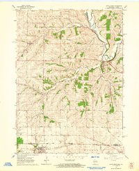
1962 Map of Apple River
USGS Topo · Published 1964About this map
The Pecatonica River winds through the northern portion of this map, defining a landscape at the Wisconsin-Illinois border where rail transport once dictated the flow of local commerce. Near Riverside, the Chicago Milwaukee St Paul and Pacific line parallels the river, while further south, the Illinois Central serves Apple River and Warren. This mid-century survey documents a rural society built around small school districts and family burial grounds, such as Dublin Sch, Red Rock Sch, and Highland Cem. The presence of an Old Railroad Grade north of Wolf Creek indicates the shifting nature of the regional transit network as older routes were superseded. Numerous quarries scattered across the townships of Darlington, Gratiot, and Monticello point to a local industry tied directly to the underlying limestone and geology of the driftless area.
Find a feature on this map
30 named features on this map. Tap any name to fly to it.
Don’t see what you’re looking for? This feature index may not catch every label — zoom into the map to look around manually.
Map Details
Editions of this 1962 Apple River Map
This is the sole edition of this map. No revisions or reprints were ever made.
Other maps of this area

1902 · Mineral Point
USGS Topo · 1:125,000

1911 · Elizabeth
USGS Topo · 1:62,500

1923 · South Wayne
USGS Topo · 1:62,500

1936 · Elizabeth
USGS Topo · 1:62,500

1937 · Lena
USGS Topo · 1:48,000

1942 · Lena
USGS Topo · 1:62,500

1943 · Lena
USGS Topo · 1:62,500

1952 · Shullsburg
USGS Topo · 1:24,000

1952 · Calamine
USGS Topo · 1:24,000

1954 · Rockford
USGS Topo · 1:250,000