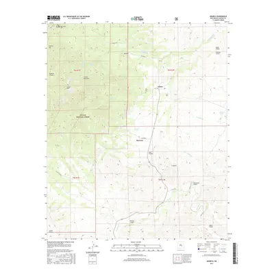
2017 Map of Arabela
USGS Topo · Published 2017About this map
Arabela and the neighboring community of S Arabela anchor this high-elevation landscape in eastern Lincoln County. The terrain is defined by the sharp transition from the Lincoln National Forest in the west, home to peaks like Boy Scout Mtn and Sunset Peak, to the drainage networks of the east. Water sources appear as critical landmarks for local history, with Las Palas Spring, Pino Real Spring, and Bluewater Spring scattered across the mountain flanks. These springs likely dictated the placement of small settlements and the Las Palas Cem. Deep canyons including Duran Canyon, Pancho Canyon, and Diablo Canyon carve through the limestone-dominated geography, while seasonal watercourses like Zeufeldt Arroyo and Agua Chiquita Cr direct the flow toward the lower basins. The map illustrates a sparse but resilient network of mountain ranches and outposts like Pine Lodge and Ramirez.
Find a feature on this map
39 named features on this map. Tap any name to fly to it.
Don’t see what you’re looking for? This feature index may not catch every label — zoom into the map to look around manually.
Map Details
Editions of this 2017 Arabela Map
This is the sole edition of this map. No revisions or reprints were ever made.
Other maps of this area

1935 · Capitan Mountains
USGS Topo · 1:48,000

1936 · Arabela
USGS Topo · 1:48,000

1940 · Capitan Mountains
USGS Topo · 1:62,500

1942 · Arabela
USGS Topo · 1:62,500

1955 · Roswell
USGS Topo · 1:250,000

1958 · Roswell
USGS Topo · 1:250,000

1961 · Lincoln
USGS Topo · 1:62,500

1961 · Tinnie
USGS Topo · 1:62,500

1962 · Roswell
USGS Topo · 1:250,000
1981 · Kyle Harrison Canyon
USGS Topo · 1:24,000