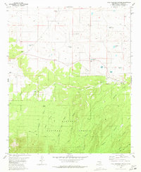
1981 Map of Kyle Harrison Canyon
USGS Topo · Published 1981About this map
Lincoln National Forest dominates the southern half of this New Mexico landscape, where the terrain breaks into a complex network of drainages including Kyle Harrison Canyon and Seco Canyon. Surveyed in the early 1980s, the map illustrates a landscape defined by seasonal water management, featuring numerous named catchments such as Antelope Lake, Cactus Flat Lake, and Cocklebur Lake. A quiet human presence is marked by the Pleasant View Cem and isolated water sources like Kyle Harrison Spring and Millset Spring. The northern reaches transition into more open country, dotted with scattered livestock tanks and wells, while a Pack Trail winds through the southern ridges, reflecting the traditional methods of traversing these remote canyons before more modern road development.
Find a feature on this map
27 named features on this map. Tap any name to fly to it.
Don’t see what you’re looking for? This feature index may not catch every label — zoom into the map to look around manually.
Map Details
Editions of this 1981 Kyle Harrison Canyon Map
This is the sole edition of this map. No revisions or reprints were ever made.
Other maps of this area

1935 · Capitan Mountains
USGS Topo · 1:48,000

1936 · Arabela
USGS Topo · 1:48,000

1940 · Capitan Mountains
USGS Topo · 1:62,500

1942 · Arabela
USGS Topo · 1:62,500

1955 · Roswell
USGS Topo · 1:250,000

1958 · Roswell
USGS Topo · 1:250,000

1962 · Roswell
USGS Topo · 1:250,000
1981 · Capitan Pass
USGS Topo · 1:24,000
1981 · Pedernal Arroyo
USGS Topo · 1:24,000

1981 · Huff Hill
USGS Topo · 1:24,000