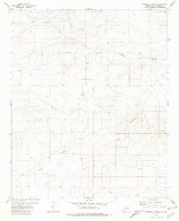
1981 Map of Pedernal Arroyo
USGS Topo · Published 1981About this map
Pedernal Arroyo and Arroyo del Macho dominate this Lincoln County landscape, illustrating a drainage system of ephemeral watercourses typical of the New Mexico high desert. Based on 1970s aerial photography and field checking, the map documents the sparse but vital water infrastructure required for ranching and land use in this arid region. The presence of named water points like Old Hogadero Well, Hogadero Well, and the Nix Tank reservoir suggests the historical importance of specific groundwater sites for local cattle or sheep operations. Beyond the natural hydrology of Hasperos Canyon and Hogadero Draw, the map indicates localized industrial activity through a Gravel Pit located near the center of the quadrangle. This detailed topographic study preserves the naming conventions and terrain features of the area before modern land-use shifts.
Find a feature on this map
9 named features on this map. Tap any name to fly to it.
Don’t see what you’re looking for? This feature index may not catch every label — zoom into the map to look around manually.
Map Details
Editions of this 1981 Pedernal Arroyo Map
This is the sole edition of this map. No revisions or reprints were ever made.
Other maps of this area

1935 · Capitan Mountains
USGS Topo · 1:48,000

1936 · Arabela
USGS Topo · 1:48,000

1940 · Capitan Mountains
USGS Topo · 1:62,500

1942 · Arabela
USGS Topo · 1:62,500

1955 · Roswell
USGS Topo · 1:250,000

1958 · Roswell
USGS Topo · 1:250,000

1962 · Roswell
USGS Topo · 1:250,000

1981 · Huff Hill
USGS Topo · 1:24,000
1981 · Encinoso
USGS Topo · 1:24,000
1981 · Kyle Harrison Canyon
USGS Topo · 1:24,000