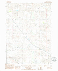
1985 Map of Arabia
USGS Topo · Published 1985About this map
Arabia stands as a quiet focal point along the Chicago and North Western rail line in the Nebraska Sandhills during the mid-1980s. This landscape is defined by the complex hydrology of Cherry County, where the Ainsworth Canal cuts across the southern terrain to manage water resources in this semi-arid region. The map documents a transition between natural watercourses like Evergreen Creek and engineered irrigation systems, reflecting the agricultural adaptations of the era. To the north, the headwaters of Fairfield and its South Fork meander through the undulating topography, while several irrigation wells labeled Irr Well indicate the reliance on groundwater for local ranching and farming operations. The rail corridor provides the primary infrastructure link through this sparsely populated territory, connecting the small settlement of Arabia to the broader regional economy.
Find a feature on this map
10 named features on this map. Tap any name to fly to it.
Don’t see what you’re looking for? This feature index may not catch every label — zoom into the map to look around manually.
Map Details
Editions of this 1985 Arabia Map
This is the sole edition of this map. No revisions or reprints were ever made.
Other maps of this area

1950 · Norden
USGS Topo · 1:62,500

1950 · Sparks
USGS Topo · 1:62,500

1950 · Wood Lake
USGS Topo · 1:62,500

1950 · Arabia
USGS Topo · 1:62,500

1952 · Norden
USGS Topo · 1:62,500

1957 · Valentine
USGS Topo · 1:250,000

1959 · Valentine
USGS Topo · 1:250,000
1983 · Muleshoe Creek
USGS Topo · 1:24,000
1983 · Thatcher
USGS Topo · 1:24,000
1983 · Sparks SE
USGS Topo · 1:24,000