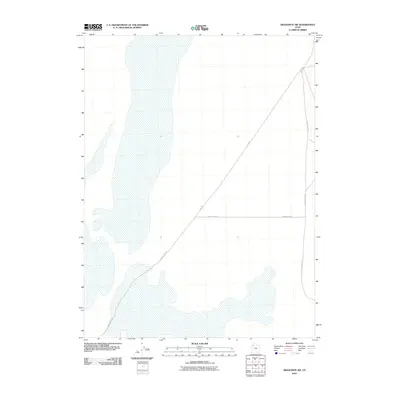
2010 Map of Aragonite SW
USGS Topo · Published 2010About this map
Tooele County's high desert landscape is defined here by the crossing of remote travel corridors in the Great Salt Lake Desert. The terrain is marked by expansive alkaline flats and mudflats, where the geography is shaped by water drainage and seasonal shifts rather than permanent settlements. Infrastructure in this region is limited to essential desert routes, most notably the long diagonal stretch of Clive Rd, which intersects with White Rocks Rd in the center of the quadrangle. These roads reflect the sparse, functional nature of land use in this part of Utah, where transportation networks must span wide distances of arid basin floor. To the east, Skull Valley Rd runs north-south, providing a primary link through the valley, while White Rock Rd winds through the southwestern corner, following the subtle shifts in the desert floor's elevation.
Find a feature on this map
4 named features on this map. Tap any name to fly to it.
Don’t see what you’re looking for? This feature index may not catch every label — zoom into the map to look around manually.
Map Details
Editions of this 2010 Aragonite SW Map
This is the sole edition of this map. No revisions or reprints were ever made.
Other maps of this area

1953 · Tooele
USGS Topo · 1:250,000

1954 · Wildcat Mtn
USGS Topo · 1:24,000

1954 · Wig Mtn NW
USGS Topo · 1:24,000

1955 · Wig Mtn NE
USGS Topo · 1:24,000

1955 · Tooele
USGS Topo · 1:250,000

1973 · Knolls
USGS Topo · 1:24,000

1973 · Aragonite NW
USGS Topo · 1:24,000

1973 · Knolls SE
USGS Topo · 1:24,000

1973 · Aragonite SE
USGS Topo · 1:24,000

1973 · Aragonite SW
USGS Topo · 1:24,000