
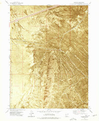
1973 Map of Aragonite SW
USGS Topo · Published 1977About this map
The Wendover Air Force Range dominates this orthophotomap of the Tooele County desert, showcasing a landscape defined by military utility and harsh natural terrain. Produced in the early 1970s using aerial photography, the imagery captures the shifting patterns of Sand Dunes and the stark expanse of a Mud Flat that interrupt the arid basin. This map is an orthophotomosaic, which overlays traditional topographic contour lines directly onto photographic imagery to provide an exceptionally clear view of ground conditions and vegetation patterns as they existed in 1972. The boundaries of several townships, including T 2 S T 3 S and T 3 S T 4 S, are delineated across the desert floor, marking the intersection of public land surveys within this remote testing and training environment.
Find a feature on this map
6 named features on this map. Tap any name to fly to it.
Don’t see what you’re looking for? This feature index may not catch every label — zoom into the map to look around manually.
Map Details
Editions of this 1973 Aragonite SW Map
This is the sole edition of this map. No revisions or reprints were ever made.
Other maps of this area

1953 · Tooele
USGS Topo · 1:250,000

1954 · Wildcat Mtn
USGS Topo · 1:24,000

1954 · Wig Mtn NW
USGS Topo · 1:24,000

1955 · Wig Mtn NE
USGS Topo · 1:24,000

1955 · Tooele
USGS Topo · 1:250,000

1973 · Knolls
USGS Topo · 1:24,000

1973 · Aragonite NW
USGS Topo · 1:24,000

1973 · Knolls SE
USGS Topo · 1:24,000

1973 · Aragonite SE
USGS Topo · 1:24,000
1973 · Aragonite
USGS Topo · 1:24,000