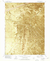
1973 Map of Aragonite
USGS Topo · Published 1977About this map
Aragonite and Clive stand as solitary markers of human activity in this high-desert stretch of Tooele County during the early 1970s. The landscape is defined by the sweeping Ripple Valley and the prominent ridges near Hickman. This orthophotomap emphasizes the stark transition between the flat valley floor and the textured, rising terrain of the surrounding mountains. Transportation and water are the primary drivers of settlement here, with the Western Pacific railroad providing a vital corridor through the basin. Sources of water like the Deseret Well were essential for sustaining life and industry in this arid environment, where the infrastructure of the rail line connects these isolated outposts to the broader region.
Find a feature on this map
8 named features on this map. Tap any name to fly to it.
Don’t see what you’re looking for? This feature index may not catch every label — zoom into the map to look around manually.
Map Details
Editions of this 1973 Aragonite Map
This is the sole edition of this map. No revisions or reprints were ever made.
Other maps of this area

1885 · Tooele Valley
USGS Topo · 1:250,000

1953 · Tooele
USGS Topo · 1:250,000

1955 · Tooele
USGS Topo · 1:250,000

1973 · Ripple Valley
USGS Topo · 1:24,000

1973 · Low
USGS Topo · 1:24,000

1973 · Quincy Spring
USGS Topo · 1:24,000

1973 · Aragonite NW
USGS Topo · 1:24,000

1973 · Grayback Hills
USGS Topo · 1:24,000

1973 · Hastings Pass
USGS Topo · 1:24,000

1973 · Aragonite SE
USGS Topo · 1:24,000