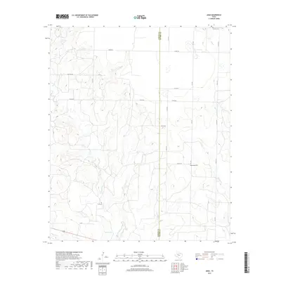
2019 Map of Arah
USGS Topo · Published 2019About this map
The county line between Borden and Scurry counties bisects this High Plains landscape, where the terrain transitions from flat mesas into the breaks carved by local waterways. Drainage patterns are dominated by the intermittent flow of Gavett Creek, Mooar Creek, and Deep Creek, which have sculpted the land into a series of draws and ridges. For genealogists and local historians, the map identifies small, significant sites of early settlement and burial, most notably York Cemetery in the southern portion and Fluvanna Cemetery near the northern boundary. The road network, including FM 1269 and numerous designated county roads like Hughes Road, follows the section lines of this agricultural and ranching region, anchored by landmarks such as Hathaway Hill and the small catchment of Holmes Lake.
Find a feature on this map
27 named features on this map. Tap any name to fly to it.
Don’t see what you’re looking for? This feature index may not catch every label — zoom into the map to look around manually.
Map Details
Editions of this 2019 Arah Map
This is the sole edition of this map. No revisions or reprints were ever made.
Other maps of this area

1951 · Ira NW
USGS Topo · 1:24,000

1952 · Ira NE
USGS Topo · 1:24,000

1954 · Dermott
USGS Topo · 1:24,000

1954 · Big Spring
USGS Topo · 1:250,000

1958 · Big Spring
USGS Topo · 1:250,000

1969 · Gail NE
USGS Topo · 1:24,000

1969 · Arah
USGS Topo · 1:24,000

1969 · Fluvanna
USGS Topo · 1:24,000
1969 · Fivemile Creek
USGS Topo · 1:24,000

1969 · Flat Top Mountain
USGS Topo · 1:24,000