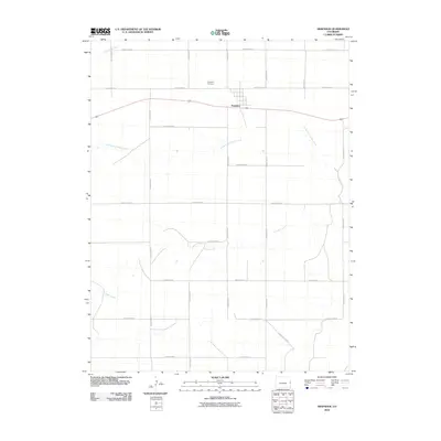
2010 Map of Arapahoe
USGS Topo · Published 2010About this map
Arapahoe sits as a central hub in this high plains landscape, defined by a rigid grid of agricultural roads that intersect the natural meanders of the western waterways. The community is situated just south of the Arapahoe Cemetery, where the land begins to slope toward the drainage of the North Fork Ladder Creek. This survey captures the region's reliance on a vast network of numbered county routes, such as County Road U and County Road L, which provide structure to the open ranching and farming territory of eastern Cheyenne County. To the north, the Smoky Hill River cuts across the corner of the quadrangle, while the southern reach is dominated by the winding path of Ladder Creek. The presence of these creeks amidst the rectilinear road system illustrates the ongoing adaptation of local settlement to the intermittent water sources of the Colorado plains.
Find a feature on this map
22 named features on this map. Tap any name to fly to it.
Don’t see what you’re looking for? This feature index may not catch every label — zoom into the map to look around manually.
Map Details
Editions of this 2010 Arapahoe Map
This is the sole edition of this map. No revisions or reprints were ever made.
Other maps of this area

1892 · Cheyenne Wells
USGS Topo · 1:125,000

1894 · Cheyenne Wells
USGS Topo · 1:125,000

1954 · Lamar
USGS Topo · 1:250,000

1958 · Lamar
USGS Topo · 1:250,000

1969 · Arapahoe SE
USGS Topo · 1:24,000

1969 · Cheyenne Wells 4 NE
USGS Topo · 1:24,000
1969 · Arapahoe NE
USGS Topo · 1:24,000

1981 · Cheyenne Wells
USGS Topo · 1:100,000
1982 · Arapahoe NW
USGS Topo · 1:24,000
1982 · Cheyenne Wells NE
USGS Topo · 1:24,000