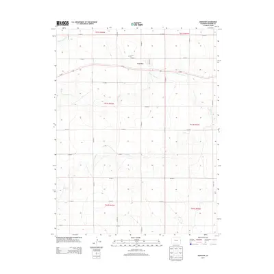
2013 Map of Arapahoe
USGS Topo · Published 2013About this map
Arapahoe sits as a primary settlement in this corner of Cheyenne County, oriented along Us-40 E and the local grid of Michigan Ave. The surrounding High Plains landscape is defined by the ephemeral drainage patterns of the Smoky Hill River in the northwest and the branching systems of N Fork Ladder Cr and Ladder Cr to the south. This 2013 survey reflects a highly organized section line road system, from CO Road U down to CO Road L, illustrating the enduring importance of the Public Land Survey System in defining eastern Colorado's geography. Genealogists and local historians can locate the Arapahoe Cem, situated just west of the town center, which serves as a central landmark for the area's rural community.
Find a feature on this map
29 named features on this map. Tap any name to fly to it.
Don’t see what you’re looking for? This feature index may not catch every label — zoom into the map to look around manually.
Map Details
Editions of this 2013 Arapahoe Map
This is the sole edition of this map. No revisions or reprints were ever made.
Other maps of this area

1892 · Cheyenne Wells
USGS Topo · 1:125,000

1894 · Cheyenne Wells
USGS Topo · 1:125,000

1954 · Lamar
USGS Topo · 1:250,000

1958 · Lamar
USGS Topo · 1:250,000

1969 · Arapahoe SE
USGS Topo · 1:24,000

1969 · Cheyenne Wells 4 NE
USGS Topo · 1:24,000
1969 · Arapahoe NE
USGS Topo · 1:24,000

1981 · Cheyenne Wells
USGS Topo · 1:100,000
1982 · Arapahoe NW
USGS Topo · 1:24,000
1982 · Cheyenne Wells NE
USGS Topo · 1:24,000