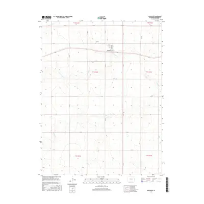
2016 Map of Arapahoe
USGS Topo · Published 2016About this map
The high plains settlement of Arapahoe serves as the focal point of this Eastern Colorado landscape, situated along the corridor of Front St and the parallel rail lines. This 2016 survey illustrates the grid of the small town, including residential thoroughfares like Michigan Ave and Iowa Ave. North of the town center, the Arapahoe Cem is a significant site for genealogical research, marking the community's history on the open prairie. The surrounding terrain is defined by the drainage systems of the Smoky Hill River in the northwest and the winding paths of N Fork Ladder Cr and Ladder Cr to the south. An extensive network of county roads, such as Co Rd U and Co Rd 56, sections the land into vast agricultural plots, reflecting the region's enduring cattle and farming economy.
Find a feature on this map
31 named features on this map. Tap any name to fly to it.
Don’t see what you’re looking for? This feature index may not catch every label — zoom into the map to look around manually.
Map Details
Editions of this 2016 Arapahoe Map
This is the sole edition of this map. No revisions or reprints were ever made.
Other maps of this area

1892 · Cheyenne Wells
USGS Topo · 1:125,000

1894 · Cheyenne Wells
USGS Topo · 1:125,000

1954 · Lamar
USGS Topo · 1:250,000

1958 · Lamar
USGS Topo · 1:250,000

1969 · Arapahoe SE
USGS Topo · 1:24,000

1969 · Cheyenne Wells 4 NE
USGS Topo · 1:24,000
1969 · Arapahoe NE
USGS Topo · 1:24,000

1981 · Cheyenne Wells
USGS Topo · 1:100,000
1982 · Arapahoe NW
USGS Topo · 1:24,000
1982 · Cheyenne Wells NE
USGS Topo · 1:24,000