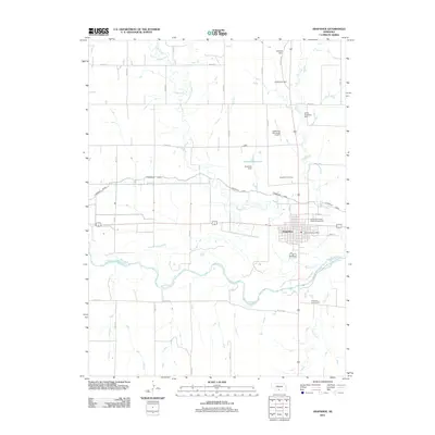
2011 Map of Arapahoe
USGS Topo · Published 2011About this map
The Republican River and the Cambridge Canal anchor this section of southern Nebraska, where the town of Arapahoe sits at the convergence of several key waterways. This area exhibits a complex network of agricultural infrastructure, including numerous family-named dams like Leissing Dam, Dickmeyer Dam, and Golter Overflow Dam. The landscape is defined by the winding paths of Muddy Creek and Elk Creek as they move toward the river valley. Local landmarks such as the Arapahoe Cemetery, the Arapahoe Post Office, and the Arapahoe Municipal Airport provide essential reference points for genealogists and local historians. To the north of the main settlement, Krumme Reservoir and its associated Krumme Dam highlight the regional reliance on water management for the plains environment. The map also documents recreational spaces like the Shady Rest Camp Motel Campground and the Arapahoe Golf Course, which serve the community along the transit corridor of the Republican River.
Find a feature on this map
39 named features on this map. Tap any name to fly to it.
Don’t see what you’re looking for? This feature index may not catch every label — zoom into the map to look around manually.
Map Details
Editions of this 2011 Arapahoe Map
This is the sole edition of this map. No revisions or reprints were ever made.
Other maps of this area

1896 · Arapahoe
USGS Topo · 1:125,000

1898 · Arapahoe
USGS Topo · 1:125,000

1954 · McCook
USGS Topo · 1:250,000

1955 · Grand Island
USGS Topo · 1:250,000

1957 · McCook
USGS Topo · 1:250,000

1957 · Grand Island
USGS Topo · 1:250,000

1958 · McCook
USGS Topo · 1:250,000

1958 · Grand Island
USGS Topo · 1:250,000

1958 · Edison
USGS Topo · 1:24,000
1958 · Arapahoe
USGS Topo · 1:24,000