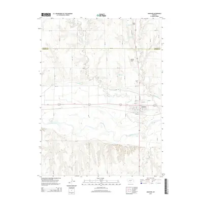
2014 Map of Arapahoe
USGS Topo · Published 2014About this map
The Republican River and its accompanying Cambridge Canal define the southern valley of this landscape, where the settlement of Arapahoe sits at the intersection of Us-34 and Us-283. The town's grid is meticulously detailed, including residential streets like Cherry St, Walnut St, and Pine St north of the river banks. To the north, the terrain becomes increasingly undulating, marked by numerous small-scale water management features including Union Ridge Reservoir, Leissing Reservoir, and Krumme Reservoir. This area highlights the critical nature of water control for agriculture and ranching on the high plains. Local history researchers can identify the location of the Arapahoe Cem north of town and the Arapahoe Municipal Airport tucked between the drainages of Muddy Cr and Elk Cr. The boundary line between Gosper Co and Furnas Co divides the upper third of the quadrangle, illustrating the regional political geography.
Find a feature on this map
44 named features on this map. Tap any name to fly to it.
Don’t see what you’re looking for? This feature index may not catch every label — zoom into the map to look around manually.
Map Details
Editions of this 2014 Arapahoe Map
This is the sole edition of this map. No revisions or reprints were ever made.
Other maps of this area

1896 · Arapahoe
USGS Topo · 1:125,000

1898 · Arapahoe
USGS Topo · 1:125,000

1954 · McCook
USGS Topo · 1:250,000

1955 · Grand Island
USGS Topo · 1:250,000

1957 · McCook
USGS Topo · 1:250,000

1957 · Grand Island
USGS Topo · 1:250,000

1958 · McCook
USGS Topo · 1:250,000

1958 · Grand Island
USGS Topo · 1:250,000

1958 · Edison
USGS Topo · 1:24,000
1958 · Arapahoe
USGS Topo · 1:24,000