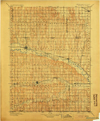
1896 Map of Arapahoe
USGS Topo · Published 1904About this map
The Republican River valley forms the primary corridor for commerce and settlement across south-central Nebraska in the late nineteenth century. Parallel to the river, the Burlington and Missouri River railroad connects established valley towns like Arapahoe and Oxford, highlighting the critical relationship between water and rail transport in this prairie landscape. An early Irrigating Ditch near Arapahoe points to the beginnings of agricultural water management in the region. To the south, Beaver Creek and Sappa Creek provide secondary water sources for smaller communities such as Stamford and Hendley. The grid of township names, including New Era and Spring Grove, reflects the systematic organization of the land as it was settled and developed for farming in the years following the 1893 survey.
Find a feature on this map
71 named features on this map. Tap any name to fly to it.
Don’t see what you’re looking for? This feature index may not catch every label — zoom into the map to look around manually.
Map Details
Editions of this 1896 Arapahoe Map
3 editions found
Other maps of this area

1893 · Norton
USGS Topo · 1:125,000

1893 · Phillipsburg
USGS Topo · 1:125,000

1896 · Lexington
USGS Topo · 1:125,000

1896 · Holdrege
USGS Topo · 1:125,000

1896 · Kearney
USGS Topo · 1:125,000

1896 · Arapahoe
USGS Topo · 1:125,000

1898 · Arapahoe
USGS Topo · 1:125,000

1899 · Lexington
USGS Topo · 1:125,000

1902 · Gothenburg
USGS Topo · 1:125,000

1951 · Norton
USGS Topo · 1:62,500