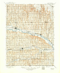
1896 Map of Arapahoe
USGS Topo · Published 1949About this map
Beaver City and Arapahoe serve as primary hubs along the drainage basins of the Republican and Beaver valleys during the late nineteenth century. This survey, conducted under the direction of Henry Gannett, illustrates a landscape defined by the Burlington and Missouri River railroad corridor, which parallels the Republican River through Edison and Oxford. The map captures an era of developing agricultural infrastructure, notably an Irrigating Ditch near Arapahoe, signaling early efforts to manage water in this prairie region. Township divisions like Union, East Turkey Creek, and Spring Grove organize the terrain between major watercourses such as Sappa Creek and Muddy Creek. Small rail stops and settlements including Hendley, Stamford, and Mascot are documented here, providing a clear record of the area's civil and commercial layout before the turn of the century.
Find a feature on this map
55 named features on this map. Tap any name to fly to it.
Don’t see what you’re looking for? This feature index may not catch every label — zoom into the map to look around manually.
Map Details
Editions of this 1896 Arapahoe Map
3 editions found
Other maps of this area

1893 · Norton
USGS Topo · 1:125,000

1893 · Phillipsburg
USGS Topo · 1:125,000

1896 · Lexington
USGS Topo · 1:125,000

1896 · Holdrege
USGS Topo · 1:125,000

1896 · Kearney
USGS Topo · 1:125,000

1896 · Arapahoe
USGS Topo · 1:125,000

1898 · Arapahoe
USGS Topo · 1:125,000

1899 · Lexington
USGS Topo · 1:125,000

1902 · Gothenburg
USGS Topo · 1:125,000

1951 · Norton
USGS Topo · 1:62,500