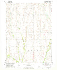
1971 Map of Arapahoe NW
USGS Topo · Published 1973About this map
Muddy Creek and its numerous tributaries dominate this early 1970s survey of the rural Divide between Frontier and Gosper counties. The landscape is defined by a dense network of watercourses, including East Muddy Creek, Elder Creek, and West Muddy Creek, which have carved deep drainages into the Nebraska prairie. For the genealogist or local historian, the map identifies several rural landmarks that anchor the community's history, most notably the Salem West Cem, Salem East Cem, Pleasant Grove Cem, and East Muddy Cem. These burial grounds, often associated with early homesteading families and now-vanished congregations, are scattered across the uplands. The distribution of these features suggests a pattern of decentralized settlement typical of the High Plains, where farmsteads were tied to the proximity of reliable water and established township lines.
Find a feature on this map
19 named features on this map. Tap any name to fly to it.
Don’t see what you’re looking for? This feature index may not catch every label — zoom into the map to look around manually.
Map Details
Editions of this 1971 Arapahoe NW Map
This is the sole edition of this map. No revisions or reprints were ever made.
Other maps of this area

1896 · Lexington
USGS Topo · 1:125,000

1896 · Arapahoe
USGS Topo · 1:125,000

1898 · Arapahoe
USGS Topo · 1:125,000

1899 · Lexington
USGS Topo · 1:125,000

1902 · Gothenburg
USGS Topo · 1:125,000

1954 · McCook
USGS Topo · 1:250,000

1955 · Grand Island
USGS Topo · 1:250,000

1957 · McCook
USGS Topo · 1:250,000

1957 · Grand Island
USGS Topo · 1:250,000

1958 · McCook
USGS Topo · 1:250,000