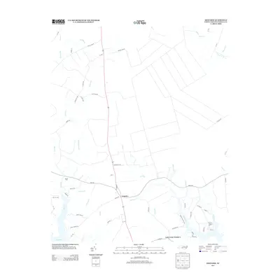
2013 Map of Arapahoe
USGS Topo · Published 2013About this map
Arapahoe serves as the central hub for this portion of Pamlico County, situated where the road network converges near the headwaters of Dawson Cr. The landscape is defined by the broad Neuse River to the south and an intricate system of brackish creeks and tidal inlets, including Beard Creek, Greens Cr, and Neal Creek. The mapping reveals a distinct agricultural and residential pattern, with numerous family-named landmarks such as Scott Town Rd, Brinson Field Rd, and Marvin Field Rd reflecting deep-rooted local heritage. Along the riverfront, Red Hill Lndg and the settlement of Cash Corner Number 2 indicate a long-standing relationship with the water. The drainage is meticulously detailed through various "guts" like Purifoy Gut and Cedar Gut, which illustrate the low-lying, watery nature of the coastal plain.
Find a feature on this map
68 named features on this map. Tap any name to fly to it.
Don’t see what you’re looking for? This feature index may not catch every label — zoom into the map to look around manually.
Map Details
Editions of this 2013 Arapahoe Map
This is the sole edition of this map. No revisions or reprints were ever made.
Other maps of this area

1948 · Oriental
USGS Topo · 1:24,000

1949 · Havelock
USGS Topo · 1:24,000

1949 · Merrimon
USGS Topo · 1:24,000

1949 · Cherry Point
USGS Topo · 1:24,000

1950 · Vandemere
USGS Topo · 1:24,000

1950 · Upper Broad Creek
USGS Topo · 1:24,000

1950 · Arapahoe
USGS Topo · 1:24,000

1951 · Arapahoe
USGS Topo · 1:24,000
1951 · Merrimon
USGS Topo · 1:24,000
1951 · Cherry Point
USGS Topo · 1:24,000