
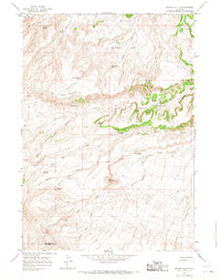
1965 Map of Arapahoe Ranch
USGS Topo · Published 1968About this map
Wind River Indian Reservation Boundary cuts across this high-elevation landscape, defining the northern edge of tribal lands in Hot Springs County. The map focuses on the complex drainage systems of North Fork Owl Creek and South Fork Owl Creek as they flow eastward from the high ridges. At the heart of this cattle-ranching country is the Arapahoe Ranch, a central node in an area defined by its named water sources. Numerous isolated springs, such as Chokecherry Spring, Blue Hill Spring, and Boghole Spring, illustrate the critical importance of water rights and livestock management in this arid terrain. Topographical landmarks like Padlock Rim and Blue Ridge rise above the deep cuts of Pumpkin Draw and Duncan Draw, showing the erosion patterns typical of the Wyoming basin. A single Oil Well suggests the early influence of the energy industry on this remote ranching landscape.
Find a feature on this map
26 named features on this map. Tap any name to fly to it.
Don’t see what you’re looking for? This feature index may not catch every label — zoom into the map to look around manually.
Map Details
Editions of this 1965 Arapahoe Ranch Map
This is the sole edition of this map. No revisions or reprints were ever made.
Other maps of this area

1913 · Grass Creek Basin
USGS Topo · 1:62,500

1914 · Blue Mesa
USGS Topo · 1:62,500

1915 · Grass Creek Basin
USGS Topo · 1:62,500

1916 · Blue Mesa
USGS Topo · 1:62,500

1952 · Kates Basin
USGS Topo · 1:24,000

1952 · Sheep Ridge
USGS Topo · 1:24,000

1955 · Thermopolis
USGS Topo · 1:250,000

1958 · Thermopolis
USGS Topo · 1:250,000

1962 · Thermopolis
USGS Topo · 1:250,000
1965 · Potato Butte
USGS Topo · 1:24,000