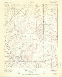
1949 Map of Arbuckle Hill
USGS Topo · Published 1953About this map
Fort Sill Military Reservation dominates this landscape north of Lawton, showing the intensive land use of the late 1940s. The map documents an intricate network of tactical features, including the Small Arms Range, Rifle Range, and the North Field landing area. Cultural landmarks reflecting the area's heritage and administration are clearly marked, such as the Indian Cem and the Indian School located near the southern reservation boundary.
Find a feature on this map
53 named features on this map. Tap any name to fly to it.
Don’t see what you’re looking for? This feature index may not catch every label — zoom into the map to look around manually.
Map Details
Editions of this 1949 Arbuckle Hill Map
2 editions found
Other maps of this area

1946 · Lawton
USGS Topo · 1:62,500

1949 · Arbuckle Hill
USGS Topo · 1:24,000

1949 · Cement
USGS Topo · 1:62,500

1949 · Elgin
USGS Topo · 1:24,000

1949 · Fort Sill
USGS Topo · 1:24,000

1949 · Nellie
USGS Topo · 1:62,500

1955 · Lawton
USGS Topo · 1:250,000

1956 · Sterling
USGS Topo · 1:24,000

1956 · Ninemile Creek
USGS Topo · 1:24,000

1956 · Fletcher
USGS Topo · 1:24,000
Featured Places
- Lawton, OK
- South East Corner Landing Strip, OK
- Pig Farm Crossing, Lawton
- Beef Flats, Lawton
- Dempsey Bridge, Lawton