
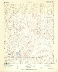
1949 Map of Arbuckle Hill
USGS Topo · Published 1953About this map
The Fort Sill Military Reservation dominates this Oklahoma landscape, illustrating the mid-century intersection of military training grounds and regional history. This 1949 field survey records a topography named for the Indigenous peoples of the southern plains, including Geronimo Hill, Comanche Hill, Kiowa Hill, and Caddo Hill. Near the East Cache Creek bottomlands, the Indian School and an Indian Cem reflect the area's cultural heritage. Strategic infrastructure is visible throughout, from the St Louis San Francisco railroad cutting through the northwest to the tactical Rifle Range and several water tanks like I-See-O Tank. The transition from the alluvial flats at Beef Flats to the high ground of Arbuckle Hill underscores the varied terrain used for maneuvers and local agriculture alike.
Find a feature on this map
47 named features on this map. Tap any name to fly to it.
Don’t see what you’re looking for? This feature index may not catch every label — zoom into the map to look around manually.
Map Details
Editions of this 1949 Arbuckle Hill Map
2 editions found
Other maps of this area

1946 · Lawton
USGS Topo · 1:62,500

1949 · Cement
USGS Topo · 1:62,500

1949 · Elgin
USGS Topo · 1:24,000

1949 · Fort Sill
USGS Topo · 1:24,000

1949 · Nellie
USGS Topo · 1:62,500

1955 · Lawton
USGS Topo · 1:250,000

1956 · Sterling
USGS Topo · 1:24,000

1956 · Ninemile Creek
USGS Topo · 1:24,000

1956 · Fletcher
USGS Topo · 1:24,000

1956 · Arbuckle Hill
USGS Topo · 1:24,000
Featured Places
- Lawton, OK
- South East Corner Landing Strip, OK
- Beef Flats, Lawton
- Pig Farm Crossing, Lawton
- Dempsey Bridge, Lawton