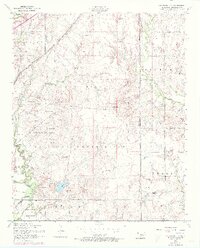
1956 Map of Arbuckle Hill
USGS Topo · Published 1973About this map
The Fort Sill Military Reservation dominates this landscape north of Lawton, Oklahoma, serving as a concentrated zone of mid-century tactical training and tribal history. Named landmarks such as Geronimo Hill, Comanche Hill, and Kiowa Hill rise above the terrain, reflecting the deep ties between the U.S. Army and the Indigenous communities of the region. The presence of the Fort Sill Indian School and an Indian Cemetery further underscore this significance, situated near the winding course of East Cache Creek.
Find a feature on this map
55 named features on this map. Tap any name to fly to it.
Don’t see what you’re looking for? This feature index may not catch every label — zoom into the map to look around manually.
Map Details
Editions of this 1956 Arbuckle Hill Map
4 editions found

Other maps of this area

1946 · Lawton
USGS Topo · 1:62,500

1949 · Arbuckle Hill
USGS Topo · 1:24,000

1949 · Cement
USGS Topo · 1:62,500

1949 · Elgin
USGS Topo · 1:24,000

1949 · Fort Sill
USGS Topo · 1:24,000

1949 · Nellie
USGS Topo · 1:62,500

1955 · Lawton
USGS Topo · 1:250,000

1956 · Sterling
USGS Topo · 1:24,000

1956 · Ninemile Creek
USGS Topo · 1:24,000

1956 · Fletcher
USGS Topo · 1:24,000
Featured Places
- Lawton, OK
- South East Corner Landing Strip, OK
- Pig Farm Crossing, Lawton
- Beef Flats, Lawton
- Dempsey Bridge, Lawton