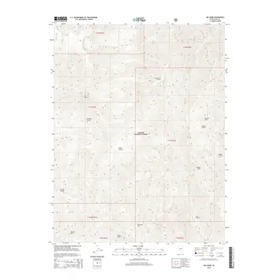
2014 Map of Arc Dome
USGS Topo · Published 2014About this map
Toiyabe National Forest encompasses this high-elevation landscape in the Toiyabe Range, dominated by the massive crest of Arc Dome and its Southeast Summit. The terrain is defined by deep drainages and canyons that carve through the mountains, including Belcher Canyon, Jett Canyon, and Niagara Canyon. Water patterns are distinct, with the Reese River flowing along the western slopes while the N Twin River and S Twin River extend eastward toward the Big Smoky Valley. High-altitude landmarks such as Toiyabe Dome and Mahogany Mtn anchor the southern and eastern reaches of the quadrangle. Historically, this area has served as a critical watershed and grazing ground, evidenced by features like South Twin Pasture, reflecting the long-standing land use within Nevada's Great Basin mountain ranges.
Find a feature on this map
32 named features on this map. Tap any name to fly to it.
Don’t see what you’re looking for? This feature index may not catch every label — zoom into the map to look around manually.
Map Details
Editions of this 2014 Arc Dome Map
This is the sole edition of this map. No revisions or reprints were ever made.
Other maps of this area

1907 · Tonopah
USGS Topo · 1:250,000

1908 · Tonopah
USGS Topo · 1:250,000

1956 · Tonopah
USGS Topo · 1:250,000

1959 · Tonopah
USGS Topo · 1:250,000

1962 · Tonopah
USGS Topo · 1:250,000

1971 · Carvers NW
USGS Topo · 1:24,000

1971 · Carvers
USGS Topo · 1:24,000

1971 · Pablo Canyon Ranch
USGS Topo · 1:24,000
1979 · Corral Wash
USGS Topo · 1:24,000
1979 · Toiyabe Peak
USGS Topo · 1:24,000