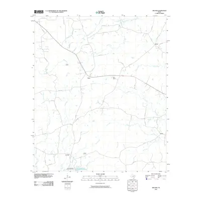
2010 Map of Arcadia
USGS Topo · Published 2010About this map
Arcadia and Huber anchor this rural Shelby County landscape, where the road network transitions from state highways like FM 138 to a dense grid of county routes. The terrain is defined by a complex drainage system flowing toward the southeast, with Poor Joe Creek and West Creek feeding into the larger watercourses. For local historians, the map preserves the location of Mount Gideon Cemetery near Huber and Powdrill Cemetery north of Arcadia, marking the community foundations of this East Texas timber and farming region.
Find a feature on this map
54 named features on this map. Tap any name to fly to it.
Don’t see what you’re looking for? This feature index may not catch every label — zoom into the map to look around manually.
Map Details
Editions of this 2010 Arcadia Map
This is the sole edition of this map. No revisions or reprints were ever made.
Other maps of this area

1953 · Palestine
USGS Topo · 1:250,000

1957 · Palestine
USGS Topo · 1:250,000

1958 · Center
USGS Topo · 1:62,500

1958 · San Augustine
USGS Topo · 1:62,500

1958 · Martinsville
USGS Topo · 1:62,500

1958 · Timpson
USGS Topo · 1:62,500

1984 · Palestine
USGS Topo · 1:250,000
1984 · Center
USGS Topo · 1:24,000
1984 · Tenaha East
USGS Topo · 1:24,000
1984 · Garrison East
USGS Topo · 1:24,000