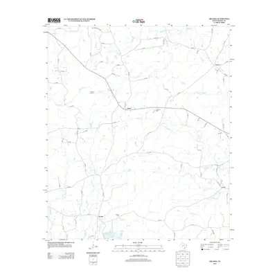
2013 Map of Arcadia
USGS Topo · Published 2013About this map
Arcadia and its surrounding rural landscapes are defined by a complex web of small creeks and bayous that drain the Piney Woods of Shelby County. Small settlements such as Huber, Lamar, and Folsom are connected by a network of county roads and farm-to-market routes like FM-138. The presence of Mt Gillion Cem and Powdrill Cem indicates established family roots and community centers in this part of East Texas. To the north, the terrain reaches a high point at Timpson Lookout, overlooking the watersheds of Bear Bayou and Penson Cr. Local water management is visible through the Soil Conservation Service Site 15 Reservoir, while the meandering paths of Huana Cr and Irish Cr illustrate the naturally low-lying, well-watered topography of the region.
Find a feature on this map
74 named features on this map. Tap any name to fly to it.
Don’t see what you’re looking for? This feature index may not catch every label — zoom into the map to look around manually.
Map Details
Editions of this 2013 Arcadia Map
This is the sole edition of this map. No revisions or reprints were ever made.
Other maps of this area

1953 · Palestine
USGS Topo · 1:250,000

1957 · Palestine
USGS Topo · 1:250,000

1958 · Center
USGS Topo · 1:62,500

1958 · San Augustine
USGS Topo · 1:62,500

1958 · Martinsville
USGS Topo · 1:62,500

1958 · Timpson
USGS Topo · 1:62,500

1984 · Palestine
USGS Topo · 1:250,000
1984 · Center
USGS Topo · 1:24,000
1984 · Tenaha East
USGS Topo · 1:24,000
1984 · Garrison East
USGS Topo · 1:24,000