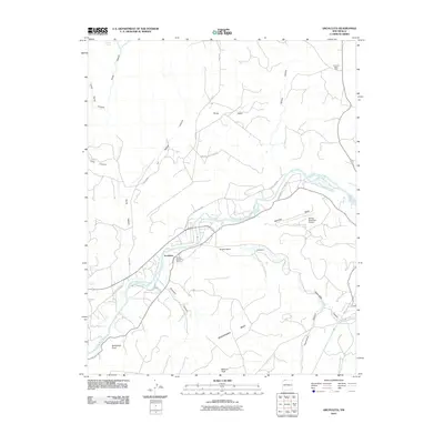
2010 Map of Archuleta
USGS Topo · Published 2010About this map
The San Juan River defines the central axis of this landscape, where the settlement of Archuleta and the Navajo Dam Post Office serve as focal points for the surrounding mesa country. The map illustrates a region transitioning between water management and energy extraction, characterized by the proximity of Navajo Lake State Park to the San Juan Basin Field. Uplands like Manzanares Mesa and Martinez Mesa are deeply incised by a network of drainage systems, including Pump Canyon, Gobernador Canyon, and Simon Canyon.
Find a feature on this map
26 named features on this map. Tap any name to fly to it.
Don’t see what you’re looking for? This feature index may not catch every label — zoom into the map to look around manually.
Map Details
Editions of this 2010 Archuleta Map
This is the sole edition of this map. No revisions or reprints were ever made.
Other maps of this area

1889 · Largo
USGS Topo · 1:250,000

1895 · Largo
USGS Topo · 1:250,000

1954 · Pine River
USGS Topo · 1:24,000
1954 · Burnt Mesa
USGS Topo · 1:24,000

1954 · Aztec
USGS Topo · 1:250,000

1958 · Aztec
USGS Topo · 1:250,000

1959 · Gould Pass
USGS Topo · 1:62,500

1959 · Aztec
USGS Topo · 1:62,500

1959 · Navajo Dam
USGS Topo · 1:62,500

1960 · Bloomfield
USGS Topo · 1:62,500