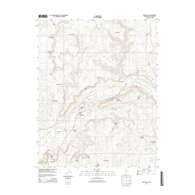
2013 Map of Archuleta
USGS Topo · Published 2013About this map
Archuleta and the massive infrastructure of the Navajo Dam anchor this northern New Mexico landscape where the high desert meets engineered water management. The San Juan River carves through a network of steep-walled drainages, including Gobernador Canyon and La Manga Canyon, revealing a terrain of mesas and peaks like Martinez Mesa and Baltazar Peak. This 2013 survey illustrates the intersection of recreation and industry, showing the Navajo Lake Airport and Cottonwood Campground alongside the San Juan Basin Field, indicating active resource extraction in the region. Local landmarks such as the Gobernador Canyon Arch and named water sources like Quintana Spring provide specific points of interest for those studying the physical geography and land use of San Juan County. A web of state and local routes, including NM-511 and various county roads, connects the scattered settlements and industrial sites across the varied elevation of the San Juan Basin.
Find a feature on this map
37 named features on this map. Tap any name to fly to it.
Don’t see what you’re looking for? This feature index may not catch every label — zoom into the map to look around manually.
Map Details
Editions of this 2013 Archuleta Map
This is the sole edition of this map. No revisions or reprints were ever made.
Other maps of this area

1889 · Largo
USGS Topo · 1:250,000

1895 · Largo
USGS Topo · 1:250,000

1954 · Pine River
USGS Topo · 1:24,000
1954 · Burnt Mesa
USGS Topo · 1:24,000

1954 · Aztec
USGS Topo · 1:250,000

1958 · Aztec
USGS Topo · 1:250,000

1959 · Gould Pass
USGS Topo · 1:62,500

1959 · Aztec
USGS Topo · 1:62,500

1959 · Navajo Dam
USGS Topo · 1:62,500

1960 · Bloomfield
USGS Topo · 1:62,500