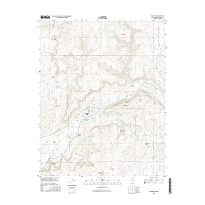
2017 Map of Archuleta
USGS Topo · Published 2017About this map
Navajo Dam controls the flow of the San Juan River in this high-desert landscape, where the small community of Archuleta sits just downstream of the impoundment. The terrain is characterized by a complex network of drainage systems, including Gobernador Canyon and Simon Canyon, which carve through prominent elevations like Pump Mesa and Martinez Mesa. This 2017 survey illustrates the modern infrastructure serving the area, such as Navajo Lake Airport and a series of rural routes including Navajo Dam Rd and Girito Rd. Significant landmarks for navigation and local history are documented here, ranging from the Gobernador Canyon Arch to high points like Baltazar Peak and Melquadis Point. Water sources critical to this arid environment, such as Quintana Spring and Prado Spring, are also specifically identified.
Find a feature on this map
39 named features on this map. Tap any name to fly to it.
Don’t see what you’re looking for? This feature index may not catch every label — zoom into the map to look around manually.
Map Details
Editions of this 2017 Archuleta Map
This is the sole edition of this map. No revisions or reprints were ever made.
Other maps of this area

1889 · Largo
USGS Topo · 1:250,000

1895 · Largo
USGS Topo · 1:250,000

1954 · Pine River
USGS Topo · 1:24,000
1954 · Burnt Mesa
USGS Topo · 1:24,000

1954 · Aztec
USGS Topo · 1:250,000

1958 · Aztec
USGS Topo · 1:250,000

1959 · Gould Pass
USGS Topo · 1:62,500

1959 · Aztec
USGS Topo · 1:62,500

1959 · Navajo Dam
USGS Topo · 1:62,500

1960 · Bloomfield
USGS Topo · 1:62,500