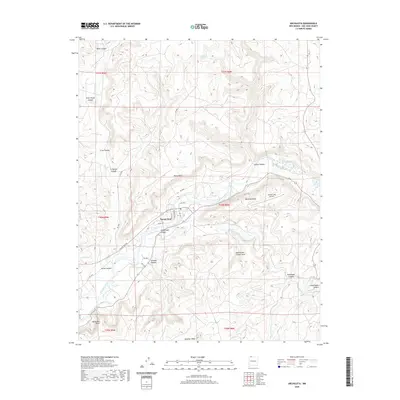
2020 Map of Archuleta
USGS Topo · Published 2020About this map
Navajo Dam and its surrounding canyonlands define this portion of the San Juan River valley in northern San Juan County. The topography is dominated by a complex network of drainage systems, including Gobernador Canyon, Simon Canyon, and Crow Canyon, which carve through prominent landforms like Pump Mesa and Martinez Mesa. This 2020 survey reveals a landscape largely shaped by water management and natural landmarks, such as the Gobernador Canyon Arch and the high elevation of Baltazar Peak at the southern edge. The area serves as a transit point for local aviation via the Navajo Lake Airport and is crisscrossed by numerous rural routes like Navajo Dam Rd and Co Rd 4275. Small water sources such as Quintana Spring and Prado Spring are scattered throughout the mesas, indicating the traditional importance of these points in an otherwise arid environment.
Find a feature on this map
36 named features on this map. Tap any name to fly to it.
Don’t see what you’re looking for? This feature index may not catch every label — zoom into the map to look around manually.
Map Details
Editions of this 2020 Archuleta Map
This is the sole edition of this map. No revisions or reprints were ever made.
Other maps of this area

1889 · Largo
USGS Topo · 1:250,000

1895 · Largo
USGS Topo · 1:250,000

1954 · Pine River
USGS Topo · 1:24,000
1954 · Burnt Mesa
USGS Topo · 1:24,000

1954 · Aztec
USGS Topo · 1:250,000

1958 · Aztec
USGS Topo · 1:250,000

1959 · Gould Pass
USGS Topo · 1:62,500

1959 · Aztec
USGS Topo · 1:62,500

1959 · Navajo Dam
USGS Topo · 1:62,500

1960 · Bloomfield
USGS Topo · 1:62,500