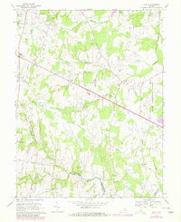
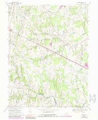
1968 Map of Arcola
USGS Topo · Published 1978About this map
Dulles International Airport occupies the eastern edge of this landscape, marking the intersection of modern infrastructure with the rural tradition of Loudoun County. This 1968 field-checked record, with later revisions, shows a region in transition as residential and industrial expansion begins to edge into agricultural lands. Small crossroads communities like Arcola and Lenah serve as focal points along the historic thoroughfare of Braddock Road, while local life is anchored by country sanctuaries such as Mt Zion Ch and Little River Ch. In the southwest, the State Prison Camp No 26 stands near the winding course of Black Br. The map also preserves the site of Oak Hill (Historical), providing a valuable reference for genealogists tracking family lands near Conklin or the waters of Broad Run and South Fork Broad Run.
Find a feature on this map
28 named features on this map. Tap any name to fly to it.
Don’t see what you’re looking for? This feature index may not catch every label — zoom into the map to look around manually.
Map Details
Editions of this 1968 Arcola Map
5 editions found
Other maps of this area

1884 · Harpers Ferry
USGS Topo · 1:125,000

1890 · Mt. Vernon
USGS Topo · 1:125,000

1891 · Harpers Ferry
USGS Topo · 1:125,000

1891 · Mt. Vernon
USGS Topo · 1:125,000

1893 · Frederick
USGS Topo · 1:125,000

1893 · Harpers Ferry
USGS Topo · 1:125,000

1894 · Warrenton
USGS Topo · 1:125,000

1894 · Frederick
USGS Topo · 1:125,000

1894 · Mt. Vernon
USGS Topo · 1:125,000

1897 · Mt. Vernon
USGS Topo · 1:125,000