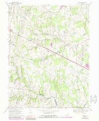
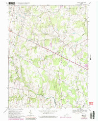
1968 Map of Arcola
USGS Topo · Published 1989About this map
Arcola and its rural Loudoun County surroundings are documented here during a period of transition as the capital's suburban reach began to expand westward. The landscape is defined by traditional Virginia watercourses like Broad Run and Bull Run, yet modern infrastructure is increasingly prominent. The eastern edge is dominated by the sprawling grounds of Dulles International Airport, while the interior of the map reveals a network of country lanes connecting long-standing local landmarks such as Mt Zion Ch and Little River Ch.
Find a feature on this map
27 named features on this map. Tap any name to fly to it.
Don’t see what you’re looking for? This feature index may not catch every label — zoom into the map to look around manually.
Map Details
Editions of this 1968 Arcola Map
5 editions found
Other maps of this area

1884 · Harpers Ferry
USGS Topo · 1:125,000

1890 · Mt. Vernon
USGS Topo · 1:125,000

1891 · Harpers Ferry
USGS Topo · 1:125,000

1891 · Mt. Vernon
USGS Topo · 1:125,000

1893 · Frederick
USGS Topo · 1:125,000

1893 · Harpers Ferry
USGS Topo · 1:125,000

1894 · Warrenton
USGS Topo · 1:125,000

1894 · Frederick
USGS Topo · 1:125,000

1894 · Mt. Vernon
USGS Topo · 1:125,000

1897 · Mt. Vernon
USGS Topo · 1:125,000