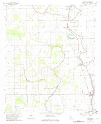
1967 Map of Arcola
USGS Topo · Published 1982About this map
Arcola and its neighboring delta settlements are defined by a complex network of bayous and drainage systems that dictate the agricultural layout of the 1960s. The Illinois Central railroad runs north-south, connecting the community of Burdette with the industrial infrastructure of the region. Meandering water bodies like Deer Creek and Black Bayou carve through the terrain, while landmarks such as Huddleston Lake highlight the characteristic oxbow formations of the Mississippi Delta. This landscape is dotted with numerous country churches and burial grounds, such as Mt Zion Ch and the Wilmot Cem, providing a detailed record of the area's rural social fabric. The presence of the Frazier Landing Field and a separate Landing Strip near Arcola suggests the importance of aerial crop dusting and agricultural aviation in this fertile corner of Washington County.
Find a feature on this map
33 named features on this map. Tap any name to fly to it.
Don’t see what you’re looking for? This feature index may not catch every label — zoom into the map to look around manually.
Map Details
Editions of this 1967 Arcola Map
2 editions found
Other maps of this area

1939 · Readland
USGS Topo · 1:62,500

1939 · Refuge
USGS Topo · 1:62,500

1939 · Tralake
USGS Topo · 1:62,500

1939 · Swan Lake
USGS Topo · 1:62,500

1953 · Greenwood
USGS Topo · 1:250,000

1956 · Greenwood
USGS Topo · 1:250,000
1967 · Tribbett
USGS Topo · 1:24,000

1967 · Arcola
USGS Topo · 1:24,000

1967 · Leland
USGS Topo · 1:24,000
1967 · Holly Ridge
USGS Topo · 1:24,000