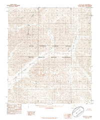
1983 Map of Arctic D-1
USGS Topo · Published 1986About this map
The Continental Divide serpentines through this high-latitude terrain, marking the hydrological boundary where mountain waters begin their long journeys to separate oceans. In this unroaded expanse within the Arctic National Wildlife Refuge, the landscape is defined by the sharp relief of the Brooks Range and the glacial pathways of the East Fork Chandalar River. Historically significant for its absence of permanent settlements, the region is crossed only by natural features such as Guilbeau Pass. The inclusion of the Arctic Wildlife Refuge Wilderness designation reflects the formal protection of this environment during the early 1980s, providing a look at one of the most intact ecosystems in North America through the lens of a provisional U.S. Geological Survey topographic study.
Find a feature on this map
5 named features on this map. Tap any name to fly to it.
Don’t see what you’re looking for? This feature index may not catch every label — zoom into the map to look around manually.
Map Details
Editions of this 1983 Arctic D-1 Map
2 editions found
Other maps of this area

1951 · Demarcation Point
USGS Topo · 1:250,000

1951 · Arctic
USGS Topo · 1:250,000

1951 · Table Mountain
USGS Topo · 1:250,000

1951 · Mt. Michelson
USGS Topo · 1:250,000

1955 · Demarcation Point
USGS Topo · 1:250,000

1956 · Table Mountain
USGS Topo · 1:250,000

1956 · Arctic
USGS Topo · 1:250,000

1956 · Mt. Michelson
USGS Topo · 1:250,000

1964 · Table Mountain
USGS Topo · 1:250,000

1964 · Demarcation Point
USGS Topo · 1:250,000