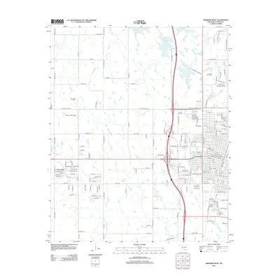
2012 Map of Ardmore West
USGS Topo · Published 2012About this map
Lone Grove and the western reaches of the regional hub define this landscape at the start of the 2010s, showing a transition from dense street grids to open prairie and ranch land. The area is notable for its numerous burial grounds, including Saint Marys Cem, Mt Zion Cem, and Rose Hill Cem, which offer significant value for genealogical research in Carter County. Water resources like the Noble-Sea Cattle Company Reservoir and Caddo Cr drain the northern sections, while the western corridor is punctuated by aviation landmarks such as Taliaferro Field Airport and Colby Field Airport. This period shows the area's established road network, from named city streets like Comanche St to rural routes like Stobtown Rd, reflecting the blend of residential growth and agricultural heritage characteristic of southern Oklahoma.
Find a feature on this map
173 named features on this map. Tap any name to fly to it.
Don’t see what you’re looking for? This feature index may not catch every label — zoom into the map to look around manually.
Map Details
Editions of this 2012 Ardmore West Map
This is the sole edition of this map. No revisions or reprints were ever made.
Other maps of this area

1901 · Ardmore
USGS Topo · 1:125,000

1918 · Ardmore
USGS Topo · 1:125,000

1957 · Ardmore
USGS Topo · 1:250,000

1963 · Ardmore
USGS Topo · 1:250,000

1964 · Lake Murray
USGS Topo · 1:24,000

1964 · Ardmore East
USGS Topo · 1:24,000

1964 · Ardmore West
USGS Topo · 1:24,000
1964 · Gene Autry
USGS Topo · 1:24,000

1964 · Overbrook
USGS Topo · 1:24,000

1964 · Springer
USGS Topo · 1:24,000