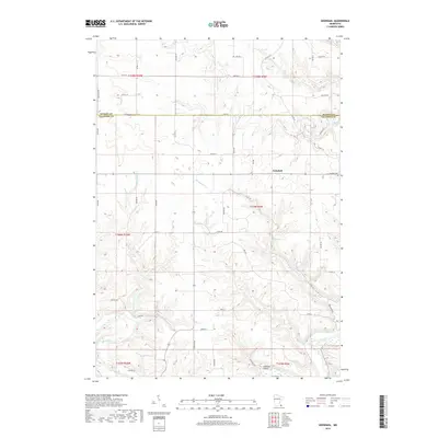
2019 Map of Arendahl
USGS Topo · Published 2019About this map
The Root River winds through the southern reaches of this landscape, where the settlement of Lobland Valley sits near the river's bend. This 2019 survey captures the rural character of Fillmore County, dominated by a complex network of waterways including Big Springs Cr and Pine Cr. Near the center of the map, the community of Arendahl serves as a local landmark, anchored by the Arendahl Cem situated along the high ground. The terrain is defined by its drainage patterns, with numerous smaller tributaries like Torkelson Cr and Hemingway Cr carving through the agricultural sections. A well-defined grid of local roads, such as Flag Rd and Doe Rd, connects isolated farmsteads and agricultural plots, while Big Springs provides a notable natural hydrological feature in the central valley.
Find a feature on this map
55 named features on this map. Tap any name to fly to it.
Don’t see what you’re looking for? This feature index may not catch every label — zoom into the map to look around manually.
Map Details
Editions of this 2019 Arendahl Map
This is the sole edition of this map. No revisions or reprints were ever made.
Other maps of this area

1954 · Chatfield
USGS Topo · 1:62,500

1954 · Lewiston
USGS Topo · 1:62,500

1954 · Mason City
USGS Topo · 1:250,000

1957 · Mason City
USGS Topo · 1:250,000

1958 · Mason City
USGS Topo · 1:250,000

1958 · La Crosse
USGS Topo · 1:250,000

1961 · La Crosse
USGS Topo · 1:250,000

1965 · La Crosse
USGS Topo · 1:250,000

1965 · Bratsberg
USGS Topo · 1:24,000
1965 · Lanesboro
USGS Topo · 1:24,000