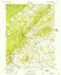
1956 Map of Arendtsville
USGS Topo · Published 1956About this map
The rural fruit-growing belt of Adams County is defined here by the winding course of Conewago Creek and the protective slopes of South Piney Mountain. This mid-century landscape is anchored by the borough of Arendtsville and the milling heritage of Eicholtz Mill, while the forested northwestern corner contains portions of the Michaux State Forest. The map captures a period of local educational consolidation, featuring the Brysonia Consolidated School alongside older landmarks like Sheelys School.
Find a feature on this map
35 named features on this map. Tap any name to fly to it.
Don’t see what you’re looking for? This feature index may not catch every label — zoom into the map to look around manually.
Map Details
Editions of this 1956 Arendtsville Map
This is the sole edition of this map. No revisions or reprints were ever made.
Other maps of this area

1904 · Carlisle
USGS Topo · 1:62,500

1908 · Gettysburg
USGS Topo · 1:62,500

1909 · Fairfield
USGS Topo · 1:62,500

1919 · Newville
USGS Topo · 1:62,500

1942 · Gettysburg
USGS Topo · 1:125,000

1943 · Carlisle
USGS Topo · 1:62,500

1944 · Gettysburg
USGS Topo · 1:31,680

1944 · Flat Ridge
USGS Topo · 1:31,680

1944 · Arendtsville
USGS Topo · 1:31,680
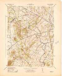
1944 · Fairfield
USGS Topo · 1:31,680
Featured Places
- Arendtsville, PA
- Southampton Township, PA
- Franklin Township, PA
- Cumberland Township, PA
- Brysonia, Menallen Township