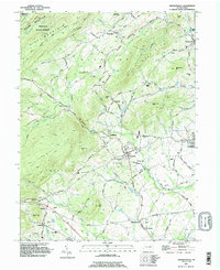
1990 Map of Arendtsville
USGS Topo · Published 1995About this map
Arendtsville and its surrounding orchard-dotted valleys are centered in this 1990 survey of northern Adams County. The landscape is defined by the transition from the ridges of South Mountain and Piney Mountain down into the productive agricultural plains of Butler and Franklin townships. The map documents numerous small settlements and social centers of the era, including the religious landmarks of St James Ch and Mt Calvary Ch, alongside the recreational grounds of Camp Nawakwa.
Find a feature on this map
76 named features on this map. Tap any name to fly to it.
Don’t see what you’re looking for? This feature index may not catch every label — zoom into the map to look around manually.
Map Details
Editions of this 1990 Arendtsville Map
This is the sole edition of this map. No revisions or reprints were ever made.
Other maps of this area

1904 · Carlisle
USGS Topo · 1:62,500

1908 · Gettysburg
USGS Topo · 1:62,500

1909 · Fairfield
USGS Topo · 1:62,500

1919 · Newville
USGS Topo · 1:62,500

1942 · Gettysburg
USGS Topo · 1:125,000

1943 · Carlisle
USGS Topo · 1:62,500

1944 · Gettysburg
USGS Topo · 1:31,680

1944 · Flat Ridge
USGS Topo · 1:31,680

1944 · Arendtsville
USGS Topo · 1:31,680
1944 · Fairfield
USGS Topo · 1:31,680
Featured Places
- Arendtsville, PA
- Southampton Township, PA
- Franklin Township, PA
- Cumberland Township, PA
- Brysonia, Menallen Township