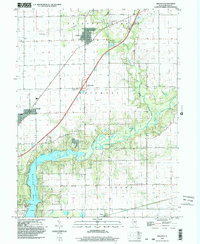
1998 Map of Argenta
USGS Topo · Published 2003About this map
Friends Creek and Kickapoo Creek flow through this section of central Illinois, converging near the agricultural settlements of Argenta and Newburg. The landscape is defined by the winding course of the Sangamon River as it enters the northern reaches of Lake Decatur, a prominent feature that reshaped the local topography. This late 20th-century survey shows the area's rural character preserved through its numerous family and community burial grounds, such as Friends Creek Cem and Ritchie Cem, alongside local landmarks like the Oakley Brick Ch. Transportation patterns are evidenced by the transition from rural roads to more modern infrastructure, including Interchange 150. Near Oreana, the map documents several industrial sites, including scattered Gravel Pits, which illustrate the region's reliance on local natural resources. The inclusion of Berry Sch and Union Ch provides essential touchpoints for those researching the social fabric of these townships.
Find a feature on this map
28 named features on this map. Tap any name to fly to it.
Don’t see what you’re looking for? This feature index may not catch every label — zoom into the map to look around manually.
Map Details
Editions of this 1998 Argenta Map
This is the sole edition of this map. No revisions or reprints were ever made.
Other maps of this area

1929 · Decatur
USGS Topo · 1:62,500

1933 · Decatur
USGS Topo · 1:62,500

1937 · Monticello
USGS Topo · 1:48,000

1943 · Monticello
USGS Topo · 1:62,500

1955 · Bement
USGS Topo · 1:62,500

1957 · Maroa
USGS Topo · 1:62,500

1958 · Peoria
USGS Topo · 1:250,000

1958 · Decatur
USGS Topo · 1:250,000

1961 · Peoria
USGS Topo · 1:250,000

1961 · Decatur
USGS Topo · 1:250,000