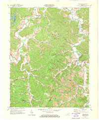
1972 Map of Argillite
USGS Topo · Published 1973About this map
The Little Sandy River carves through the undulating terrain of Greenup County, anchoring a landscape defined by small valley settlements and a pervasive extractive history. This 1970s record shows the transition from historic iron manufacturing to modern strip mining, most notably at the Furnace Ruins near Hunnewell. The northern reaches are dominated by Greenbo Lake State Park, while the rest of the quadrangle is etched with complex drainage systems like Cane Creek and Turkey Lick. The social fabric of the era is preserved through numerous family-named cemeteries such as Reeves Cem and Howard Cem, alongside landmarks like the Argillite Lookout Tower. Extensive Strip Mines and numerous Mines dot the eastern ridges, indicating the intense industrial activity that shaped the local economy and land use during this period.
Find a feature on this map
74 named features on this map. Tap any name to fly to it.
Don’t see what you’re looking for? This feature index may not catch every label — zoom into the map to look around manually.
Map Details
Editions of this 1972 Argillite Map
2 editions found
Other maps of this area

1898 · Ironton
USGS Topo · 1:62,500

1900 · Ironton
USGS Topo · 1:62,500

1901 · Ceredo
USGS Topo · 1:62,500

1903 · Kenova
USGS Topo · 1:125,000

1904 · Kenova
USGS Topo · 1:125,000

1913 · Ceredo
USGS Topo · 1:62,500

1926 · Greenup
USGS Topo · 1:48,000

1930 · Greenup
USGS Topo · 1:62,500

1953 · Grayson
USGS Topo · 1:24,000

1953 · Oldtown
USGS Topo · 1:24,000