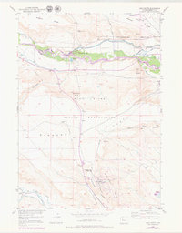
1951 Map of Argo Butte
USGS Topo · Published 1979About this map
The Wind River Indian Reservation landscape is defined by the heavy footprint of mid-century industrial and agricultural engineering. The Wind River serves as the central artery for this development, feeding the Riverton Reclamation Project via the Diversion Dam and an extensive network of waterways like the Wyoming Canal and Deshaw Ditch. This complex irrigation infrastructure converted the arid flats into productive land, a process further evidenced by the several labeled irrigation ditches, some already marked as Ditch (Aband) by the time of the 1970s revisions.
Find a feature on this map
35 named features on this map. Tap any name to fly to it.
Don’t see what you’re looking for? This feature index may not catch every label — zoom into the map to look around manually.
Map Details
Editions of this 1951 Argo Butte Map
2 editions found
Other maps of this area

1951 · Lookout Butte SW
USGS Topo · 1:24,000

1951 · Morton
USGS Topo · 1:24,000

1951 · Fort Washakie
USGS Topo · 1:24,000

1951 · Bull Lake East
USGS Topo · 1:24,000

1951 · Lookout Butte
USGS Topo · 1:24,000

1951 · Argo Butte
USGS Topo · 1:24,000

1951 · Ethete
USGS Topo · 1:24,000

1952 · Wise Flat
USGS Topo · 1:24,000

1952 · Crowheart Butte
USGS Topo · 1:24,000

1955 · Thermopolis
USGS Topo · 1:250,000