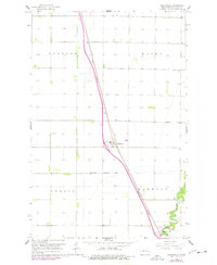
1963 Map of Argusville
USGS Topo · Published 1977About this map
Argusville serves as the central hub of this eastern North Dakota survey, situated along the Great Northern railroad corridor. The landscape is defined by the rigid geometry of agricultural township boundaries, including Gardner, Wiser, and Berlin, which are interspersed with a network of section lines and field boundaries. In the southeastern corner, the meandering Sheyenne River breaks the prairie's grid, creating a natural wooded corridor that contrasts sharply with the surrounding farmland. This area includes the recreational space of Brooktree Park. Local history is anchored by essential community landmarks such as the High School within the Argusville Corporate Limits and the Argusville Cem located to the west of the main settlement. The map captures the transition of the region as Interstate 29 begins to parallel the older rail and highway routes, signaling a shift in the local transportation network.
Find a feature on this map
13 named features on this map. Tap any name to fly to it.
Don’t see what you’re looking for? This feature index may not catch every label — zoom into the map to look around manually.
Map Details
Editions of this 1963 Argusville Map
2 editions found
Other maps of this area

1895 · Fargo
USGS Topo · 1:125,000

1895 · Casselton
USGS Topo · 1:125,000

1897 · Fargo
USGS Topo · 1:125,000

1897 · Casselton
USGS Topo · 1:125,000

1952 · Grand Forks
USGS Topo · 1:250,000

1953 · Fargo
USGS Topo · 1:250,000

1956 · Fargo
USGS Topo · 1:250,000

1956 · Grand Forks
USGS Topo · 1:250,000

1959 · Fargo North
USGS Topo · 1:24,000

1959 · West Fargo
USGS Topo · 1:24,000